


Mont Caume

Vox463
User

Length
16.4 km

Max alt
781 m

Uphill gradient
930 m
Km-Effort
29 km

Min alt
185 m

Downhill gradient
928 m
Boucle
Yes
Creation date :
2024-06-29 05:47:12.277
Updated on :
2024-06-29 08:06:28.023
6h32
Difficulty : Very difficult

FREE GPS app for hiking
 SityTrail
IGN / Geographical institutes
SityTrail Plus
The world is yours!
About
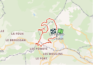
Trail Walking of 16.4 km to be discovered at Provence-Alpes-Côte d'Azur, Var, Le Revest-les-Eaux. This trail is proposed by Vox463.
Positioning
Country:
France
Region :
Provence-Alpes-Côte d'Azur
Department/Province :
Var
Municipality :
Le Revest-les-Eaux
Location:
Unknown
Start:(Dec)
Start:(UTM)
737747 ; 4784535 (31T) N.
Comments